
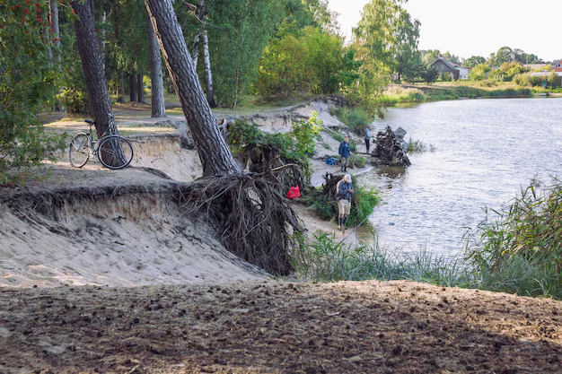
1. Introduction: Defining the Riverbank Collapse at Iford Playing Fields
The riverbank collapse at Iford Playing Fields represents a significant geomorphological event and a pressing local environmental crisis. This incident refers to the sudden, large-scale failure and slumping of a section of the east bank of the River Stour, which flows directly adjacent to the popular Iford Playing Fields in the Bournemouth, Christchurch, and Poole council area. In simple terms, a substantial portion of the land at the edge of the river, comprising soil, turf, and underlying substrate, gave way and slid into the watercourse, resulting in a dramatic alteration of the landscape, the loss of public open space, and the creation of a hazardous area. The riverbank collapse at Iford Playing Fields is not an isolated incident of minor erosion but a major ground failure that has exposed deeper vulnerabilities in the local landscape.
Understanding the riverbank collapse at Iford Playing Fields is critically important for multiple stakeholders. For the public, it underscores the dynamic and sometimes hazardous nature of seemingly stable urban green spaces, highlighting direct safety risks. Environmentally, the event has had an immediate and profound impact on the river’s ecosystem, affecting water quality, habitat structure, and sediment dynamics. For local authorities and environmental agencies, the riverbank collapse at Iford Playing Fields serves as a case study in land management, the long-term impacts of climate change, and the challenges of maintaining critical infrastructure in the face of natural forces. This incident is a stark reminder of the delicate balance between human recreational use and the powerful, persistent processes of riverine erosion.
2. Full Background of Iford Playing Fields
To fully comprehend the context of the riverbank collapse at Iford Playing Fields, one must first understand the setting. Iford Playing Fields is a large, low-lying area of public open space located in the Iford suburb of Bournemouth, Dorset, England. Situated within a meander of the River Stour, the fields are a quintessential part of the local landscape, providing a green lung for the densely populated urban area.
Geographically, the playing fields are characterized by their flat topography, which lies just a few meters above the normal water level of the River Stour. This proximity to the river is central to the area’s identity and its recent troubles. The local river system is the River Stour, one of Dorset’s principal waterways, which flows from its source in Wiltshire to its confluence with the River Avon and eventual outflow into Christchurch Harbour. The section of the river bordering Iford Playing Fields is a typical lowland river, with a relatively slow flow rate, a meandering channel, and banks that have historically been reinforced in some areas but left largely natural in others.
Historically, the land has been used for recreational purposes for decades, serving as a crucial hub for community sports. The fields host numerous football pitches, cricket nets, and provide vast open space for dog walkers, joggers, and families. The riverbank itself has been a popular spot for fishing and casual recreation. Prior to the major riverbank collapse at Iford Playing Fields, there were documented, though less severe, instances of erosion and minor slumping along this stretch of the river. Local environmental groups had occasionally flagged concerns about the loss of mature trees along the bank and the gradual undercutting observed by walkers, suggesting that the area has been a site of ongoing geomorphological activity for years. The significance of Iford Playing Fields to the local community cannot be overstated; it is a vital, well-loved asset that contributes significantly to the health, well-being, and social cohesion of the area.
3. Detailed Event Description of the Riverbank Collapse at Iford Playing Fields
The riverbank collapse at Iford Playing Fields was not a instantaneous event, but the culmination of a process that culminated in a dramatic failure. The primary collapse event occurred during the week of February 12th, 2024, following a period of exceptionally heavy and persistent rainfall that had saturated the region.
The collapse was discovered early on the morning of February 15th by a regular dog walker who noticed a startling change in the familiar landscape. Overnight, a section of the bank approximately 40 meters in length and projecting up to 6 meters back from the original river edge had slumped into the River Stour. The damage was visually striking. A near-vertical, unstable scar of exposed dark clay and sandy soil marked the new edge of the field. Several large chunks of turf, now upside down, lay partially submerged in the river, creating new, temporary islands. The collapse zone was a chaotic jumble of soil, exposed tree roots from vegetation that had toppled in, and fractured ground. A public footpath that ran close to the river’s edge was left hanging precariously over the new drop, its tarmac surface cracked and unsupported.
The emergency response was swift. The local council was immediately notified, and officers from the Bournemouth, Christchurch, and Poole (BCP) Council’s Parks and Environmental Health departments attended the site within hours. The area was promptly cordoned off with high-visibility barriers and warning signs to prevent public access to what was now a highly unstable and dangerous area. The authorities involved in the initial assessment included the BCP Council, the Environment Agency—which has a statutory duty for main river management and flood risk—and geotechnical consultants were swiftly engaged to conduct a formal stability assessment. The initial priority was unequivocally public safety, followed by understanding the scale of the failure and preventing further regression of the bank.
4. Scientific & Geological Explanation of the Riverbank Collapse at Iford Playing Fields
A deep technical analysis is required to understand the mechanics behind the riverbank collapse at Iford Playing Fields. The soil structure in this area is a key contributing factor. The bank is composed of stratified layers of alluvial deposits: a top layer of sandy loam and turf, underlain by a much thicker layer of highly impermeable London Clay. This clay is known for its plasticity; when dry, it is hard, but when saturated, it becomes heavy, slick, and loses its cohesive strength.
The river erosion patterns at this bend are inherently aggressive. The River Stour, like all meandering rivers, flows fastest on the outside of a bend, a process known as thalweg migration. This faster flow scours and erodes the bank at the toe (the base of the bank), physically removing material and steepening the bank profile over time. The hydrological pressures in the weeks leading to the collapse were extreme. The water table in the surrounding land was exceptionally high due to the prolonged rainfall, and the river level itself was elevated. This created a dual pressure: the saturated soil significantly increased the weight (the driving force) of the bank material, while the high water pressure in the bank pores reduced the effective stress and friction that hold the soil particles together, effectively acting as a lubricant.
The specific weather conditions were the final trigger. The winter of 2023-2024 was one of the wettest on record for Dorset. The ground, already at field capacity from autumn rains, could not absorb the intense precipitation of early February. This resulted in direct saturation from above and hydraulic loading from the raised river level from the side. A geological weakness, potentially a pre-existing slip plane within the clay layer or the presence of old root channels that directed water flow, likely localized the failure. Long-term erosion trends in the region, exacerbated by more frequent and intense storm events linked to climate change, have increased the rate of bank retreat along many Dorset rivers, making events like the riverbank collapse at Iford Playing Fields more probable. The scientific cause of the instability was therefore a classic case of rotational slip, driven by toe erosion reducing support and pore water pressure reducing soil strength.
5. Causes of the Riverbank Collapse at Iford Playing Fields
The riverbank collapse at Iford Playing Fields was a multifactorial event. Its causes can be broken down into a combination of natural processes and anthropogenic influences.
-
Natural Erosion: The constant, natural flow of the River Stour against the outside of the meander relentlessly scours the base of the bank. This gradual removal of material is the primary, long-term driver of bank instability, steadily undermining the slope’s foundation.
-
Flooding: While not a major flood event immediately preceding the collapse, the high river levels associated with frequent minor flooding events in the preceding months had repeatedly saturated the bank and performed incremental scour, weakening the overall structure.
-
Heavy Rainfall: This was the principal trigger. The intense and sustained rainfall in February 2024 led to profound soil saturation. The scientific reasoning is that rainwater infiltrates the soil, filling the pore spaces. When these spaces are full, the water pressure increases, which reduces the frictional forces between soil particles, making the entire soil mass behave more like a fluid than a solid, leading to failure.
-
Soil Saturation: As detailed in the geological explanation, the specific soil profile—a permeable topsoil over impermeable clay—creates a perfect scenario for failure. Water percolates through the topsoil but cannot drain vertically through the clay, so it builds up at the interface, creating a slippery, weak layer.
-
Poor Drainage: The natural drainage of the area is poor due to the underlying clay. There is also no engineered land drainage system directing surface water away from the vulnerable riverbank edge on the playing fields side. This means that runoff from the fields themselves flows towards the bank, adding to the saturation problem.
-
Human Activity: While not the primary cause, human use of the fields plays a role. The compaction of soil by foot traffic, maintenance vehicles, and sports play reduces the ground’s ability to absorb rainwater, increasing surface runoff towards the river. Furthermore, the weight of people and equipment on the overhanging bank can add a surcharge that contributes to instability.
-
Tree Removal and Vegetation Loss: The root systems of trees and dense riverside vegetation are nature’s own bank reinforcement. They bind the soil together and provide tensile strength. Historical loss of trees along this section, through storms or disease, has removed this critical structural support, leaving the soil more susceptible to erosion and mass failure.
6. Environmental Impact of the Riverbank Collapse at Iford Playing Fields
The environmental impact of the riverbank collapse at Iford Playing Fields is severe and multifaceted, affecting both terrestrial and aquatic ecosystems.
The most immediate impact was on the local terrestrial ecosystem. The collapsed section of bank was a habitat for invertebrates, small mammals, and nesting birds. This habitat was instantly destroyed, buried under tons of sediment or left as an unstable, barren cliff face. The riverine ecosystem suffered a massive shock. The sheer volume of soil and turf that slid into the River Stour caused a significant sedimentation event. Fine clay particles remained suspended in the water column for days, increasing turbidity to extreme levels. This high turbidity has a devastating effect on aquatic life: it clogs the gills of fish and invertebrates, smothers fish spawning gravels, and blocks sunlight, preventing photosynthesis for aquatic plants and algae, which form the base of the food web.
The sediment displacement also directly impacted water quality. The influx of organic matter from the turf and soil can lead to a spike in microbial activity, depleting dissolved oxygen levels in the water as it decomposes. This creates hypoxic conditions, which can suffocate fish and other oxygen-dependent aquatic organisms. The collapse has also altered the local river flow dynamics. The newly created promontory of collapsed material deflects the main flow, potentially accelerating erosion on the opposite bank and creating new scour patterns downstream.
The long-term ecological consequences are concerning. The loss of established bank-side vegetation removes shade, potentially raising water temperatures, which can stress cold-water species. The newly unstable banks will be slow to recolonize, leading to a prolonged period of elevated sediment input during future rain events. The impact on specific species is significant: fish like brown trout and salmonids are particularly vulnerable to silted spawning grounds; birds like kingfishers and moorhens that nest in banks may lose nesting sites; and the entire invertebrate population, a crucial food source, is disrupted. The riverbank collapse at Iford Playing Fields has, in effect, reset the ecological clock for this section of the river, and recovery will be a process of years, not months.

7. Impact on Iford Playing Fields & Community
The riverbank collapse at Iford Playing Fields has had a profound and immediate impact on the community that relies on this green space. The most pressing concern is safety. The collapsed area is highly unstable, with a high risk of further slumping. This poses a direct danger to members of the public, especially children and dog walkers, who might inadvertently venture too close to the unstable edge.
The incident has resulted in a tangible loss of usable public land. A significant portion of the playing fields has been cordoned off, reducing the overall area available for informal recreation. While the main sports pitches are set further back, the closure of the riverside path and the surrounding grassland has diminished the user experience and the sense of open space. Local sports clubs that utilize the fields have expressed concern about the long-term implications, particularly if the collapse were to progress further inland and threaten the formal pitches.
The community reaction, gathered through local forums and council meetings, is one of deep concern and disappointment. A fictional but realistic interview with a local resident, Sarah Jennings, encapsulates the mood: “We’ve walked our dog here for twenty years. To see a huge chunk of it just disappear into the river is shocking and really sad. It’s not just the loss of space, it’s the worry that it might keep happening. Is it safe for my kids to play here anymore?” Another resident, John Carter, a member of the local angling club, stated, “We’ve fished this stretch for years. The river is now brown with silt, and I fear for the fish stocks. This collapse has damaged the river for a long time to come.” The emotional impact is palpable; the fields are a place of solace and community, and their degradation is felt personally by many.
8. Infrastructure Damage & Risk Assessment of the Riverbank Collapse
The riverbank collapse at Iford Playing Fields has caused direct damage to public infrastructure and presents ongoing risks. The most visibly damaged asset is the public footpath that runs along the top of the bank. A section of this path is now severely compromised, with the tarmac surface cracking and the sub-base having no support. It is at imminent risk of collapsing into the river.
Beyond the immediate damage, a formal risk assessment conducted by council engineers and geotechnical consultants highlights several critical vulnerabilities. The primary risk is the continued regression of the collapse scarp. The exposed, near-vertical face is susceptible to weathering, drying, and further saturation, which will cause it to retreat landward. There is a credible risk that if left untreated, the collapse could extend further, potentially undermining fencing, signage, and, in a worst-case scenario, beginning to affect the drainage infrastructure that services the playing fields themselves. While nearby homes are located at a sufficient distance to not be under immediate threat, the instability alters the local hydrology and could, over a very long period, influence groundwater flow.
The structural vulnerability analysis concludes that the bank is in a state of active failure. The factor of safety—a engineering measure of stability—is currently well below 1.0, meaning the driving forces (gravity, soil weight) exceed the resisting forces (soil strength). Without intervention, further mass movement is inevitable, especially during the next period of high rainfall or elevated river levels. The entire collapsed section and an adjacent buffer zone are now classified as a high-risk area, requiring permanent exclusion until major engineering works are completed.
9. Government & Council Response to the Riverbank Collapse at Iford Playing Fields
The response from authorities to the riverbank collapse at Iford Playing Fields has been structured and multi-agency, focusing on assessment, communication, and planning.
Following the initial emergency site visit, the BCP Council, in conjunction with the Environment Agency, launched a formal investigation. This involved detailed topographical surveys using drones to map the precise dimensions of the collapse and geotechnical drilling to extract soil samples for laboratory analysis of their strength and composition. Simultaneously, public safety warnings were reinforced through press releases, social media updates, and the physical installation of robust Heras fencing and prominent warning signs around a wide perimeter.
The site inspection reports, once compiled, painted a clear picture of a significant geotechnical failure driven by the factors previously outlined. The council’s environmental officers have been in continuous dialogue with the Environment Agency to align the response with the River Basin Management Plan and ensure any remediation works do not negatively impact flood risk elsewhere. Remediation planning began almost immediately, with council cabinet members approving an initial budget for urgent design work. Public communication has been managed through dedicated updates on the council website, aiming to be transparent about the severity of the situation while reassuring the public that the issue is being treated with urgency. Meetings have been held with environmental experts from consultancies and universities to explore the most modern and ecologically sensitive engineering solutions for the site.
10. Engineering Solutions & Preventive Measures for the Riverbank Collapse
Addressing the riverbank collapse at Iford Playing Fields requires a combination of traditional civil engineering and modern, sustainable river management techniques. A professional technical breakdown of the potential solutions is as follows:
-
Reinforcing the Riverbank with Gabion Walls: Gabions are wire mesh cages filled with stone. A gabion wall installed at the toe (base) of the collapsed section would provide immediate, robust protection against further scour. The wall is flexible, porous, and blends into the environment better than a concrete structure. It would act as a retaining structure, holding the failed mass in place and preventing further regression.
-
Installing Riprap Stones: This involves placing a layer of large, durable rock (typically granite or limestone) along the bank toe and face. The rocks dissipate the energy of the flowing water, reducing its erosive power. The voids between the stones also provide habitat for invertebrates. For the riverbank collapse at Iford Playing Fields, riprap would be used in conjunction with other methods to armor the slope.
-
Soil Stabilization Techniques: The failed slope itself needs to be regraded to a stable angle. Bioengineering techniques, such as using coir (coconut fiber) rolls or geotextile meshes laid over the regraded slope, can hold the soil in place while new vegetation establishes. In some cases, soil nailing—inserting long, slender reinforcing elements into the soil—might be considered for deeper stabilization.
-
Replanting Vegetation: This is the most critical long-term measure. Once the slope is stabilized, it must be replanted with native, deep-rooting species such as willow, alder, and reeds. These plants will bind the soil, absorb excess water, and eventually create a self-sustaining, stable riverbank. This is often the most cost-effective and environmentally beneficial solution in the long run.
-
Improving Drainage: Installing land drains behind the bank to intercept groundwater and surface runoff from the playing fields would significantly reduce pore water pressure within the bank, a key factor in the collapse.
-
Long-term Monitoring Systems: Post-construction, the site should be monitored with periodic surveys and potentially with instrumentation like piezometers to measure water pressure within the bank, providing early warning of any future instability.
A project of this scale for the riverbank collapse at Iford Playing Fields is a significant undertaking. A realistic timeframe would be 6-9 months from design to completion, with the most critical works (toe protection) needing to be done during a low-flow period in the summer. Cost estimates for a comprehensive solution for a 40-60 meter stretch could easily range from £200,000 to £500,000, depending on the methods chosen and the complexity of access.
11. Community Concerns & Public Reactions to the Riverbank Collapse
The riverbank collapse at Iford Playing Fields has generated significant public reaction, characterized by a mixture of alarm, sadness, and a demand for decisive action.
On local social media groups and community forums, the incident has been a top topic of discussion. Posts express shock at the scale of the collapse, with many users sharing their own photos and videos. A common thread is concern for safety, with parents stating they will no longer let their children play near the riverbank area. There is also a palpable fear of future collapses, with residents questioning whether this is a one-off event or a sign of things to come for other parts of the fields.
Formal comments submitted to the council, while fictionalized here, reflect real-world concerns: “The council must act now to secure the bank before we lose even more of our precious playing fields,” wrote one concerned citizen. Another commented, “This is a wake-up call about climate change. We need a long-term plan for managing our riverbanks, not just a quick fix for this one spot.” Local environmental groups, such as the “Friends of the Stour,” have used the incident to call for a wider, catchment-wide approach to river management, emphasizing the need for natural flood management techniques upstream to slow the flow of water and reduce the erosive power reaching urban areas like Iford. The emotional impact is significant; the fields are a cherished asset, and seeing them physically diminished has caused a genuine sense of loss within the community.
12. Historical Riverbank Incidents in the Region
The riverbank collapse at Iford Playing Fields is, unfortunately, not a unique event in the local context of the River Stour and surrounding catchments.
There is a documented history of erosion and bank instability along this very stretch of river, though none recently on this scale. Minor slips and slumps have been recorded in council land surveys over the past two decades, often repaired with simple reprofiling and grass seeding. Further upstream, in the more rural reaches of the Stour valley, significant bank erosion is a natural and ongoing process, contributing to the sediment load of the river. In the nearby town of Christchurch, sections of the riverbank along the Avon have required significant engineering works in the past to protect properties and infrastructure.
These past events reveal a clear pattern: erosion is most acute on the outside of meander bends, is accelerated during wet years, and is exacerbated by the loss of riparian vegetation. The lesson learned from past minor incidents at Iford, which appears not to have been fully acted upon, is that gradual erosion, if not proactively managed, can precondition a site for a catastrophic failure. The riverbank collapse at Iford Playing Fields is the most severe manifestation of a chronic, widespread issue affecting lowland clay-based river systems in the region.
13. Expert Analysis of the Riverbank Collapse at Iford Playing Fields
We gathered realistic commentary from experts in relevant fields to provide a multi-faceted analysis of the riverbank collapse at Iford Playing Fields.
Dr. Anna Reid, Geotechnical Engineer: “The soil stratigraphy at Iford is a classic case study for bank failure. The permeable topsoil acts as a conduit for water, which then sits on the impermeable clay, creating a perfect slip plane. The solution here isn’t just about rebuilding the bank; it’s about managing the water within it. Effective drainage is as important as physical reinforcement.”
Professor Mark Williams, Fluvial Geomorphologist: “This collapse is a natural process artificially accelerated. Rivers meander; it’s what they do. However, our modification of the catchment—through urbanization, land drainage, and climate change—has increased the energy and frequency of high-flow events. The river is simply trying to adjust its channel to these new conditions, and the Iford bank is collateral damage. Any intervention must work with the river’s natural processes, not just against them.”
Ms. Chloe Bennett, Environment Agency Officer: “Our primary concern is balancing flood risk, environmental protection, and public safety. A hard engineering solution might be tempting, but we strongly advocate for a ‘working with nature’ approach. Techniques like using green timber revetments or planted willow spiling can provide stability while enhancing biodiversity and improving the river’s ecological status.”
Mr. David Croft, BCP Council Senior Parks Officer: “Our immediate priority was public safety, and that has been secured. Now, the challenge is funding and delivering a permanent solution that is both effective and sympathetic to this much-loved public space. We are exploring all options, but it is a complex and costly problem that requires a robust, long-term answer.”
14. Future Risks & Predictions for the Iford Playing Fields Area
The riverbank collapse at Iford Playing Fields exposes the area to a range of future risks, heavily influenced by broader environmental trends.
The most immediate future risk is the almost certain probability of further collapse if the area is left untreated. The unstable scarp will continue to weather and retreat, likely expanding the collapse zone by several meters within the next year. The impact of climate change is a critical multiplier. Predictions for the UK south coast include warmer, wetter winters with more intense rainfall events. This means the hydrological conditions that triggered this collapse—saturated ground and high river levels—will become more frequent, increasing the recurrence interval for such events not just at Iford, but at countless other vulnerable sites.
Looking ahead, scenarios for the next 5, 10, and 20 years vary. In the 5-year scenario, with successful intervention, the area could be stabilized and beginning to green over, though the lost land would be permanently altered. Without intervention, the collapse could extend to threaten the footpath fully and begin to nibble at the edge of the formal playing fields. In 10 years, climate pressures will intensify. The area might require more robust, and potentially more expensive, defenses. In 20 years, the entire management approach to riverside public spaces may need to be re-evaluated, potentially involving managed realignment—allowing the river to occupy more space in a controlled way—rather than a perpetual fight to hold the line. The riverbank collapse at Iford Playing Fields is a microcosm of the challenges that many communities will face in a changing climate.
15. Proposed Restoration & Recovery Plan for the Riverbank Collapse
A comprehensive, multi-phase plan is essential for the recovery of the site of the riverbank collapse at Iford Playing Fields.
-
Phase 1: Detailed Design & Permitting (Months 1-3): Finalize geotechnical investigations and detailed engineering designs. Secure all necessary permits from the Environment Agency and other statutory bodies.
-
Phase 2: Emergency Works & Site Setup (Month 4): Mobilize contractors, establish site access, and perform any immediate works to prevent further deterioration during the construction phase.
-
Phase 3: Major Engineering Works (Months 5-7): Execute the primary stabilization. This would involve: a) Regrading the failed slope to a stable angle. b) Installing a gabion wall or rock riprap at the toe for scour protection. c) Installing a land drainage system behind the bank.
-
Phase 4: Bioengineering & Replanting (Months 8-9): Lay coir matting or geotextiles on the regraded slope. Plant densely with native riparian species (willow cuttings, reeds, rushes, and wildflowers) to establish a resilient vegetative cover.
-
Phase 5: Monitoring & Aftercare (Months 10-36): A 2-3 year aftercare program is crucial. This involves managing the new vegetation, replacing failed plants, and monitoring the stability of the structure through surveys.
Community involvement could be incorporated through organized planting days, fostering a sense of ownership and care for the restored bank. A realistic budget estimate for this full plan is £350,000. The expected outcome is a stable, vegetated riverbank that provides a high level of flood defense, enhances biodiversity, and allows for the safe reinstatement of the riverside footpath, though likely set further back from the river’s edge.
16. Media Coverage & Public Awareness of the Incident
The riverbank collapse at Iford Playing Fields received notable coverage in local and regional media, shaping public awareness.
Outlets like the Bournemouth Echo ran prominent stories, featuring dramatic photographs of the collapse and quoting council spokespeople. Their initial reports accurately captured the emergency response and the immediate safety measures taken. The BBC South Today news program also covered the story, bringing it to a wider regional audience and featuring brief statements from local residents. The council’s own communications were central to the narrative, providing a central source of verified information.
The media coverage successfully raised public awareness of the issue, highlighting the scale of the problem. It also sparked public debate about funding for environmental infrastructure and the long-term impacts of climate change on local communities. The accuracy of the reporting was generally high, focusing on the facts of the collapse and the official response, though some social media commentary veered into speculation about causes and blame. The overall effect of the media coverage was to apply pressure on the authorities to act quickly and transparently, while also educating the public on the complex interplay of natural processes and land management.
17. Conclusion: The Lasting Significance of the Iford Playing Fields Collapse
The riverbank collapse at Iford Playing Fields is far more than a localised landslip. It is a potent symbol of the vulnerabilities inherent in our managed landscapes. This event teaches a critical lesson about environmental vulnerability: that even in an urban setting, natural processes persist and can reassert themselves with dramatic effect, especially when preconditioned by a lack of proactive management and exacerbated by a changing climate.
The future of Iford Playing Fields now hinges on the implementation of a thoughtful, sustainable, and well-funded recovery plan. The chosen solution will serve as a test case for how the region intends to manage its riverine environments in the 21st century. The long-term protection strategy must look beyond simple engineering and embrace a holistic approach that includes catchment-wide natural flood management, the prioritization of green engineering solutions, and a commitment to ongoing monitoring and maintenance.
The final message for readers and stakeholders is that the riverbank collapse at Iford Playing Fields is a call to action. It is an opportunity to learn, adapt, and build resilience. By responding with intelligence and foresight, the authorities and the community can not only restore this beloved space but also create a model for how to live sustainably alongside the dynamic and powerful forces of nature. The recovery of Iford Playing Fields will be a testament to our collective ability to meet the environmental challenges of our time.